Synthesis
At the step of synthesis, geophysicists need to connect the interpretation results to the geologic questions asked at set-up, and also determine whether iterations of the previous steps are necessary. At Bookpurnong, the hydrologists are primarily concerned about the salinity of the groundwater that indicates the recharge (gaining) or discharge (losing) status of the river. Both models consistently indicate that the upstream part of the river is fresher (less conductive) and thus losing water; the downstream part of the river is more saline (more conductive) and thus gaining water.
Back to the motivating questions in Setup:
How EM can be used to reconstruct an electrical conductivity model for the entire region?
Frequency-domain and time-domain EM systems were flown over the area to collect FDEM and TDEM data that are related to the codnuctivity through Maxwell’s equations. Then the measured field data were inverted to conductivities at depth using the 1D layered earth modeling. The two data sets provide consistent information about the conductivity.
Can the conductivity model, a proxy of the severity of salinization, reveal the dynamics of groundwater flow?
Yes. By examing the inverted models, we concludes that the upstream section of the river loses water, flushing the surrounding floodplain; the downstream section gains saline water rfom the highland, casuing the increase of conductivity and salinity.
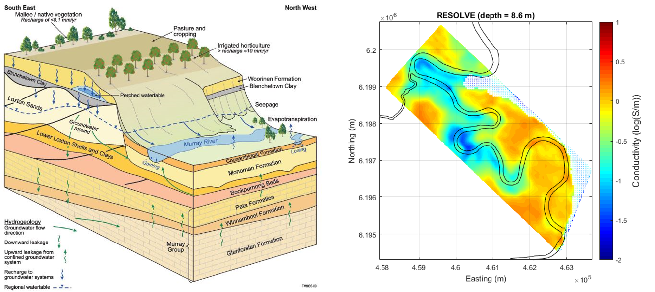
Fig. 358 Hydrological model and electrical conductivity model at Bookpurnong.
Follow up
We have notied a temporal variation in the conductivity models from SkyTEM 2006 and RESOLVE 2008. Given the importance of the temporal analysis in the water management, this is something worth further investigation and confirmation. Two approaches amy be pursued:
Iterate back to processing and do advanced analysis of hypothesis test. The idea is to test if alternative models that do not show such temporal change exist.
Incorporating additional information. There are other data available, including another RESOLVE data set in 2005 and another SkyTEM data sets in 2015, as well as some EM-31 at some locations and NanoTEM data in the river. The salinity data of water samples can also be used to help constrain the inversion.