Wadi Sabha
Airborne and Ground Time-Domain EM results from the Albany Graphite Discovery
Authors: Daniele Colombo, Gary McNeice, Diego Rovetta, Ernesto Sandoval-Curiel, Ersan Turkoglu and Armando Sena.
Editor: Devin C. Cowan, Douglas Oldenburg, Seogi Kang and Lindsey J. Heagy.
Special Thanks
Thanks to Daniele Colombo of Saudi Aramco and thanks to the Society of Exploration Geophysicists for permission to reproduce figures and adapt text from:
Daniele Colombo, Gary McNeice, Diego Rovetta, Ernesto Sandoval-Curiel, Ersan Turkoglu and Armando Sena (2016). ”High-resolution velocity modeling by seismic-airborne TEM joint inversion: A new perspective for near-surface characterization.” The Leading Edge, 35(11), 977–985. https://doi.org/10.1190/tle35110977.1
The material presented here has been modified from the SEG-published version and is subject to the SEG terms of use and conditions. This case history was presented as a part of the SEG 2017 Distinguished Instructor Short Course.
Abstract
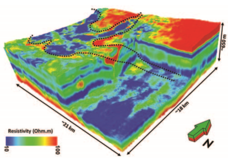
We discuss the use of helicopter-borne transient electromagnetic (HTEM) for a high-resolution spatial and vertical characterization of the near surface in a structure-controlled wadi in central Saudi Arabia. In this area, seismic data quality is poor, and seismic imaging suffers from a combination of scattering effects — due to swarms of faults reaching the surface — and large velocity variations occurring along subvertical boundaries between the wadi sediment infill and the surrounding carbonate plateaus. HTEM was selected from a suite of non-seismic methods for multiparameter velocity-model building to enhance the velocity estimation for the wadi and surrounding areas. HTEM data were modeled by performing spatially constrained 1D resistivity inversion to obtain a high-resolution image of the near surface with sensitivity to a depth of 400–500 m from the surface. Sharp boundaries of the wadi and fine vertical layering, obtained from the HTEM inversion, provide detailed information about the parameter variations in the near surface. A seismic-HTEM joint-inversion approach is developed using a cross-gradient structural operator to constrain the velocity inversion with the higher resolution HTEM data. Joint-inversion results provide sharp velocity reconstruction across the wadi boundaries and increase the dynamic range of the velocity variations when compared to a single-domain tomographic approach in which the HTEM contribution is ignored. Superior imaging results in both time and depth are derived from velocities estimated by the seismic-TEM joint-inversion approach.
Citations
[CMR+16] : High-resolution velocity modeling by seismic-airborne TEM joint inversion: A new perspective for near-surface characterization