Bookpurnong
Spatially constrained inversion for quasi 3D modelling of airborne electromagnetic data – an application for environmental assessment in the Lower Murray Region of South Australia
Authors: Andrea Viezzoli, Esben Auken, and Tim Munday
Editors: Dikun Yang
Special Thanks
Thanks to the Exploration Geophysics for permission to reproduce figures and adapt text from:
Andrea Viezzoli, Esben Auken, and Tim Munday (2009). ”Spatially constrained inversion for quasi 3D modelling of airborne electromagnetic data – an application for environmental assessment in the Lower Murray Region of South Australia.” Exploration Geophysics, 40(2), 173-183. https://doi.org/10.1071/EG08027
This case history was presented as a part of the SEG 2017 Distinguished Instructor Short Course.
Abstract
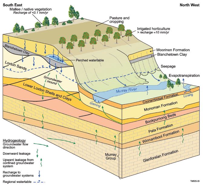
Airborne EM is an important type of survey in geophysical that can be found useful in solving different geological questions, especially the ones that require quick data coverage over a large area. Hydrological and environmental studies can be good subject of airborne EM. In this case history, airborne FDEM surveys, and airborne TDEM surveys are used to assess the salinization at a groundwater management trial site near Bookpurnong in South Australia.
The following topics are covered:
How the airborne EM can be applied in hydrogeological and environmental studies.
Airborne EM acquisition systems and airborne data.
Interpretation of airborne EM data using a 1D layered model.
Citations
[VAM09] : Spatially constrained inversion for quasi 3D modelling of airborne electromagnetic data – an application for environmental assessment in the Lower Murray Region of South Australia.