Kasted
Assessment of near-surface mapping capabilities by airborne transient electromagnetic data – an extensive comparison to conventional borehole data
Authors: A. S. H⌀yer, Troels Vilhelmsen, Esben Auken, Anders Vest Christiansen, Flemming J⌀rgensen, Peter B.E. Sandersen, Andrea Viezzoli and Ingelise M⌀ller.
Editor: Devin C. Cowan
Special Thanks
This case study was adapted from the articles “A regional scale hydrostratigraphy generated from geophysical data of varying age, type and quality by Vilhelmsen ([VMF+16]) and “3D geological modelling of a complex buried-valley network delineated from borehole and AEM data” by Høyer ([HoyerJorgensenS+15]).
Abstract
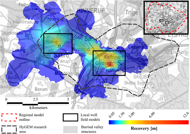
In Denmark all drinking water is groundwater. The geological setting is dominated by glaciation periods and consequently the country is rich in buried and open tunnel valleys. The buried valleys are a key factor for groundwater recharge, flow and extraction and hence a detailed delineation of the geological structures is crucial to impose an efficient water management strategy. The buried valleys are typically between 50-350 m deep and 0.5-4 km wide, and have distinct shapes such as undulating thalwegs and abrupt terminations, setting the need for a high spatial data density in order to map the water-bearing structures. Airborne TDEM, such as SkyTEM, fulfills this need with a cost-effective mapping on a regional scale. Approximately 40% of Denmark has been mapped with the SkyTEM method to delinate water bearing structures and access the vulnerability of the aquifers with respect to pollution sources. The present case study highlights one of these mappings and covers the following topics:
Airborne TDEM for hydrogeological studies on a regional scale in a sedimentary environment
Airborne TDEM acquisition and interpretation
Contents