New Thin Skinned Rock Glacier Model
The well established thin-skinned tectonic model in which nappes are transported along one or more décollements [CAB+79] of a continental mountain system is an analogue for our structural and kinematic model of the Furggwanghorn rock glacier (Fig. 421) At our study site, the major shear zone is a décollement and the rock glacier lobes are equivalent to the nappes. All lobes are presently moving downslope. As for the mountain belt example, the fault zones bounding the rock glacier lobes sole into the décollement and there is little or no displacements at greater depths. The new thin skinned rock glacier model may be applicable to many other rock glaciers.
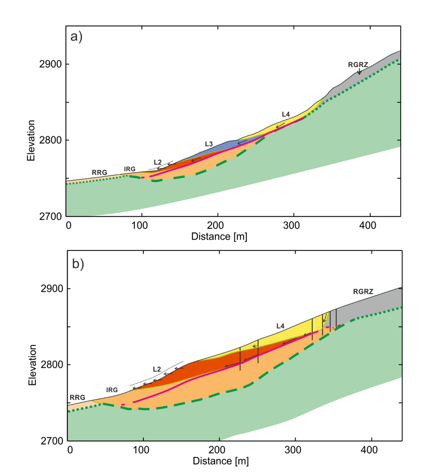
Fig. 421 Proposed thin-skinned rock glacier model. Labels are defined in the legend to Fig. 409. Green and magenta lines are the interpreted bedrock and décollement. Arrows: inferred displacements. The (a) and (b) diagrams represent models for the H4 and H5 H-GPR images (Fig. 418 and Fig. 419).
Synthesis
Can surface-based GPR surveying provide reliable subsurface information for the Furggwanghorn rock glacier? Comparing GPR images from nearly coincident lines recorded at different times are used as reliability tests.
Is it possible to improve the reliability of GPR images by recording the data using a helicopter mounted system (i.e. H-GPR)? Reliability is tested in the same manner as for the surface-based images. Although applications of the surface-based GPR method have revealed key information for many rock glaciers worldwide, our attempts using two different GPR instruments and three different antenna frequencies during three Winter / Spring periods and one Summer period failed to produce reliable information for the Furggwanghorn rock glacier. In contrast, application of the H-GPR method resulted in reliable and highly informative images of the rock glacier and bedrock. Why were the H-GPR images so much more meaningful than the surface-based ones at our survey site? One possible reason was that the shallow heterogeneities were uniformly in the far field of the H‑GPR antennae, whereas many of these heterogeneities were in the near field of the surface-based antennae. In addition, the consistency of the surface-based data was likely affected by abrupt changes in the antenna radiation patterns caused by variations in the coupling between the antennae and snow and between the antennae and underlying blocky subsurface. The radiation patterns of the H-GPR antennae, 15 ‑ 20 m above the ground, were not influenced significantly by the snow and rocks.
Is it possible to image the bedrock beneath the rock glacier using H-GPR? The interface between the rock glacier and bedrock was distinguished by a change from low reflectivity to high reflectivity along the vast majority of H-GPR images. In some regions there was a strong reflection from the interface and in others the amplitudes at the interface markedly increased with the onset of prominent dipping, curvilinear or chaotically oriented reflections.
Can H-GPR data acquired along closely spaced lines and limited intersecting lines be used to construct a dependable 3D image of the entire Furggwanghorn rock glacier? Images on adjacent and crossing lines revealed a segmented rock glacier within which the upper region comprised four reflective lobes separated by fault zones that soled into a major shear zone. The region of rock glacier underlying the major shear zone was largely nonreflective. Reflective basement was detected below the nonreflective part of the rock glacier. Borehole observations demonstrated the ice rich and ice poor nature of the upper highly reflective and low reflective regions, respectively, and determined the current movement rates across the major shear zone.
Does such a 3D GPR image provide new insights into the rock glacier’s evolution and continuing development? A combined interpretation of the H-GPR data images with information supplied by geological and geotechnical borehole observations led to a new thin skinned rock glacier model.