Lalor
3D inversion of total magnetic intensity data for time-domain EM at the Lalor massive sulphide deposit
Authors: Douglas Oldenburg and Dikun Yang
Editor: Devin C. Cowan
Special Thanks
Thanks to the Society of Exploration Geophysicists for permission to reproduce figures and adapt text from:
Yang Dikun and Oldenburg Douglas W. (2017). ”3D inversion of total magnetic intensity data for time-domain EM at the Lalor massive sulphide deposit.” Exploration Geophysics, 48(2), 110-123. https://doi.org/10.1071/EG15070
The material presented here has been modified from the SEG-published version and is subject to the SEG terms of use and conditions. This case history was presented as a part of the SEG 2017 Distinguished Instructor Short Course.
Abstract
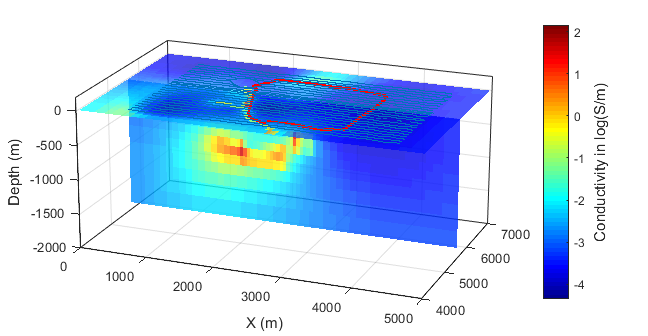
The Lalor deposit is a massive sulphide that is characterized as a stack of conductive ore lenses buried more than 600 m deep. As of 2014, the deposit has a reserve of 15.2 Mt and an inferred resource of 10.1 Mt. Compared to typical Canadian gold deposits, the Lalor lake deposit has a grade 130% above the average.
In order to characterize the Lalor lake deposit, a helicopter sub-audio magnetic (HeliSAM) survey using a ground large transmitter loop and an airborne total magnetic intensity magnetometer receiver was employed to measure the time-domain EM responses of the conductive ore bodies. Using inversion, the Lalor ore lenses as well as small sulphide-bearing argillite units were successfully imaged in 3D. The successful inversion of the geophysical data was made possible through the use of warm-start and mesh refinement algorithms.
Contents
Citations
[YO17] : 3D inversion of total magnetic intensity data for time-domain EM at the Lalor massive sulphide deposit