Red Sea
Application of Magnetotelluric and Controlled-Source Electromagnetic Methods for Subsalt Structure Imaging in the Red Sea
Authors: Daniele Colombo, Gary McNeice, Ernesto Sandoval-Curiel, Adam Fox, Nickolas Raterman, Mike Zinger and Diego Rovetta.
Editor: Devin C. Cowan and Douglas Oldenburg.
Special Thanks
Thanks to Daniele Colombo of Saudi Aramco and thanks to the Society of Exploration Geophysicists for permission to reproduce figures and adapt text from:
Daniele Colombo, Gary McNeice, Ernesto Sandoval Curiel, and Adam Fox (2013). ”Full tensor CSEM and MT for subsalt structural imaging in the Red Sea: Implications for seismic and electromagnetic integration.” The Leading Edge, 32(4), 436-449. https://doi.org/10.1190/tle32040436.1
Daniele Colombo, Gary McNeice, Nickolas Raterman, Mike Zinger, Diego Rovetta, and Ernesto Sandoval Curiel (2014). ”Exploration beyond seismic: The role of electromagnetics and gravity gradiometry in deep water subsalt plays of the Red Sea.” Interpretation, 2(3), SH33-SH53. https://doi.org/10.1190/INT-2013-0149.1
The material presented here has been modified from the SEG-published version and is subject to the SEG terms of use and conditions. This case history was presented as a part of the SEG 2017 Distinguished Instructor Short Course.
Abstract
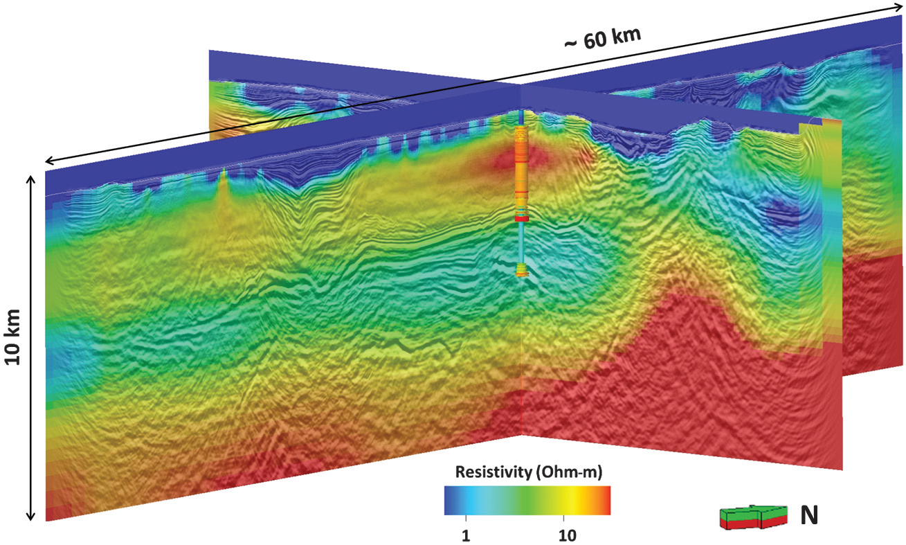
Fig. 517 Resistivity structure obtained through data-driven inversion of MT data.
The Red Sea is characterized by thick salt sequences representing a seal for potential hydrocarbon accumulations within Tertiary formations deposited over deep basement structures. The Red Sea “salt” is characterized by halite concentrations embedded in layered evaporite sequences composed of evaporite and clastic lithologies. Salt complicates seismic exploration efforts in the Red Sea by generating vertical and lateral velocity variations that are difficult to estimate by seismic methods alone. In these conditions, the exploration challenges of independently imaging the subsalt section and provide enhanced velocity model building capabilities were addressed by a multi-geophysics strategy involving marine electromagnetics (magnetotellurics [MT] and controlled source electromagnetics [CSEM]) and gravity gradiometry surveys co-located with wide azimuth seismic. Three-dimensional inversion of MT and CSEM is performed first with minimal a priori constraints and then by including variable amounts of interpretation in the starting models. The internal variations in the evaporitic overburden, the subsalt, and the basement structures are independently imaged by combined electromagnetic methods and confirmed by new drilling results. CSEM, in particular, provides unprecedented detail of the internal structures within the salt overburden while magnetotellurics provides excellent reconstruction of the base of salt and basement. Gravity gradiometry shows primary sensitivity to the basement and the corresponding 3D inversion provides density distributions structurally consistent with the resistivity volumes. The common-structure, multiparameter models obtained from 3D inversion deliver additional aid to seismic interpreters to further derisk exploration in the Red Sea and provide additional detail to depth imaging velocity models. The reciprocal consistency of the obtained results show promises for extending the work to more analytical integration with seismic such as provided by joint geophysical inversion.
Citations
[CMCF13] : Full tensor CSEM and MT for subsalt structural imaging in the Red Sea: Implications for seismic and electromagnetic integration
[CMR+14] : Exploration beyond seismic: The role of electromagnetics and gravity gradiometry in deep water subsalt plays of the Red Sea