Furggwanghorn
3D Helicopter GPR surveying a rock glacier
Authors: Alan G. Green, Kaspar Merz, and Hansruedi Maurer
Reviewer: Seogi Kang, Douglas Oldenburg, and Lindsey J. Heagy
Prelude
This case history follows the use of ground-based and helicopter-borne ground-penetrating radar to map 3D geological structures below the Furggwanghorn glacier, Switzerland. Data corresponding to the case history were collected between 2010 and 2012.
Special Thanks
Thanks to the Society of Exploration Geophysicists for permission to reproduce figures and adapt text from:
Kaspar Merz, Hansruedi Maurer, Lasse Rabenstein, Thomas Buchli, Sarah M. Springman, and Matthias Zweifel (2016). ”Multidisciplinary geophysical investigations over an alpine rock glacier.” GEOPHYSICS, 81(1), WA147-WA157. https://doi.org/10.1190/geo2015-0157.1
The material presented here has been modified from the SEG-published version and is subject to the SEG terms of use and conditions. This case history was presented as a part of the SEG 2017 Distinguished Instructor Short Course.
Abstract
Extreme heterogeneity and rugged mountainous terrains characterized by steep slopes and bouldery surfaces make rock glaciers amongst the most difficult geological features to explore using surface-based geophysical techniques. Conventional ground-penetrating radar (GPR) surveys have produced valuable subsurface information for many rock glaciers, but usually only along sparse lines because of the generally challenging to treacherous recording conditions (Fig. 407 c and d). Surface-based GPR surveys of other rock glaciers have failed to yield anything meaningful. In an attempt to provide useful subsurface information for a greater number of rock glaciers and to supply reliable images of their entire 3D structures, we conducted the first ever 3D GPR survey of a rock glacier using a helicopter mounted system. Helicopter GPR (H-GPR) has previously been employed for mapping conventional glaciers. Our results suggest that the H-GPR technique would be a practical means for exploring many other difficult to access terrains.
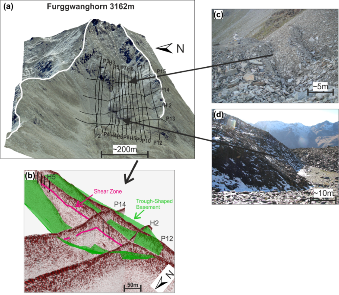
Fig. 407 Frontal view of the Furggwanghorn rock glacier showing the H-GPR lines (a). Intersecting H‑GPR sections showing the trough shaped bedrock and major shear zone (b). Typical furrows and bouldery surface of the rock glacier (c) . Steep frontal slope (d).
Citations
[MMR+16] : Multidisciplinary geophysical investigations over an alpine rock glacier