Norsminde
Assessment of near-surface mapping capabilities by airborne transient electromagnetic data – an extensive comparison to conventional borehole data
Authors: Cyril Schamper, Flemming J⌀rgensen Esben Auken and Flemming Effers⌀.
Editor: Devin C. Cowan
Special Thanks
Thanks to the Society of Exploration Geophysicists for permission to reproduce figures and adapt text from:
Cyril Schamper, Flemming Jørgensen, Esben Auken, and Flemming Effersø (2014). ”Assessment of near-surface mapping capabilities by airborne transient electromagnetic data — An extensive comparison to conventional borehole data.” GEOPHYSICS, 79(4), B187-B199. https://doi.org/10.1190/geo2013-0256.1
The material presented here has been modified from the SEG-published version and is subject to the SEG terms of use and conditions. This case history was presented as a part of the SEG 2017 Distinguished Instructor Short Course.
Abstract
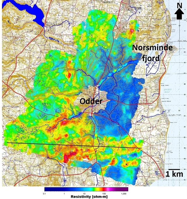
Fig. 474 Average resistivity map for a depth of 15-20 metres within the Norsminde survey region.
Groundwater models are an essential decision tool for the administration and evaluation of groundwater resources. To establish reliable models high-resolution measurements of geological structures are required putting increasing demands on the quantity, density and quality of the data collected. The financial and physical constraints of drilling make the application of near surface airborne geophysical techniques appropriate for data collection; however, is this data sufficient to have confidence in the formulation of a reliable model? To answer these questions a SkyTEM system, which special focus on the upper 30 m of the ground, was developed and tested in the Norsminde Fjord catchment in Denmark as a part of the NiCA project.
The objective of the project is to model and estimate the nitrate reduction in shallow aquifers (top 30 meters) at the scale of an entire catchment and at the resolution of each farm field. The geophysical mapping forms the basis of the detailed geological and hydrological models for determining the transport and reduction of nitrate in the catchment. In order to examine and validate the near-surface resolution of the ATDEM system and the data processing system, the geophysical results were compared with both new and existing data from drillings in the Norsminde area. All drillings within 15 metres from a flight line are included in the validation. A total of 46 drillings were within this interval. All available data from these drillings was analyzed and a detailed comparison with the geophysical models was made as showed in this case history.
Contents
Citations
[SJorgensenAEfferso14] : Assessment of near-surface mapping capabilities by airborne transient electromagnetic data - An extensive comparison to conventional borehole data